


【Contents】
- Safety measures
- Preparation of emergency supplies
- Preparation of emergency survival bags
- Confirmation of the hazard maps

- Safety measures
- What to do when a typhoon is approaching
- Pay attention to the alert level
- Confirmation of the distribution of risks (landslides, floods from inland waters and floods from rivers)
- Decide whether you should evacuate
- Cliff collapse
- landslide
- Debris flow
1.Typhoon disaster
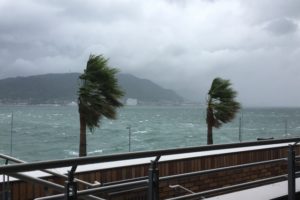
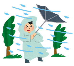
In Japan, the period from July to October is known as the typhoon season.
Typhoons cause strong winds, heavy rains, flash floods, storm surges, and high waves, as well as debris flows, cliff collapse, landslides, and flooding of rivers. In addition to natural disasters, typhoons can also cause exposure to water, power outages and water outages, which can severely affect lifelines. Roads may be blocked, railroads may be suspended and other transportation problems may occur, so extreme caution should be exercised during an approaching typhoon.
Typhoons cause damage almost every year. If a typhoon is approaching your area, you should be vigilant.

| List of typhoon damage in 2019 | |||
|---|---|---|---|
| Date | Region | Weather conditions | Disaster |
| Oct.24-26,2019 | The area centered on Chiba and Fukushima prefectures | Low pressure and the 21th typhoon of the season | Occurrence of sediment disasters, inundation damages and flooding of rivers Human and residential damage Damage such as power and water outages Traffic hindrance such as suspended operation of train |
| Oct.10-13, 2019 | A wide area, mainly in eastern Japan | The 19th typhoon of the season | Record heavy rains, storms, high waves, and storm surges Occurrence of flooding of rivers, sediment disasters and inundation damages Human and residential damage Damage to lifelines such as electricity, supplying water, roads, and railway facilities Traffic hindrance such as suspended operation of trains and planes. |
2.To prepare before a typhoon comes
To minimize the damage caused by typhoons, it is important to take precautions before the typhoons arrive, especially before the rain and wind become stronger.
① Safety measures
If a typhoon approaches, take extreme precautions both indoors and outdoors.
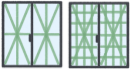
- Windows and shutters should be locked and tightly closed, and reinforced if necessary.
This is because when a typhoon approaches, there is a danger of things blowing away by
strong winds and breaking the window glass.
- Gutters and drains should be cleaned and drained to ensure good drainage.

This is because when it rains heavily, the water can’t flow properly and can overflow!

- Secure items that could be blown away by the wind or bring them into the house.
This is because potted plants can be blown away by strong winds, fall over and break.
Bicycles and motorbikes can also fall over, so secure them or move them indoors.


- Put anti-scattering film on your windows and take down the curtains and blinds in case things fly in from outside.
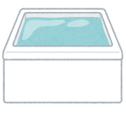
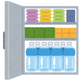
This is because strong winds and flying debris may break the window. If a window is broken, there is a risk of injury from debris. So, take precautions in advance. - Be prepared to secure drinking water and fill up your bathtub with water in case the water supply is cut off.
The water in the bath can be used for the toilet.
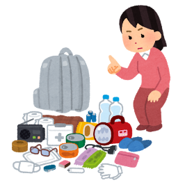
- Preparation of emergency supplies
In case of an emergency, check where the following items are located in your home. If you don’t have, prepare them.
✔ Flashlight
✔ Portable radio set(battery type)
✔ First-aid medicines
✔ Clothes
✔ Foods and beverages for emergencies
✔ Portable stove
✔ Valuables
…etc,
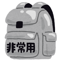
- Preparation of emergency survival bags
In order to be able to evacuate whenever you need, prepare emergency supplies in a backpack or other bags so that your hands free.
| □ Backpack | |
| Food items □ Beverages □ Foods for emergencies such as soda crackers □ Preserved foods and Canned foods □ Baby goods such as powdered milk and a baby bottle |
Daily necessities □ knife ・ can opener □ pan ・ water bottle □ Flashlight □ Portable radio set(battery type) □ batteries □ rope □ matches or lighters □ disposable body warmer □ papers such as tissues □ writing materials □ trash bags |
| Medical goods □ First-aid medicines □ Household medicines □ Masks □ Antiseptic available □ Thermometer □ Disposable diapers □ Sanitary items |
Valuables, Money □ Cash(including small change) □ Bankbook □ Personal seals □ Health insurance card □ Identification card |
| Clothes □ Thermal underwears □ Towels □ sleeping bag □ rain gear □ cotton work gloves □ shoes |
Others □ Disaster hood・helmet □ spare glasses □ maps |

- During a disaster, masks, disinfectants and thermometers are in short supply. If possible, prepare them yourselves.
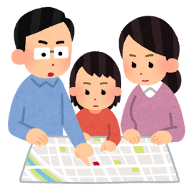
- In addition to those listed above, you should also check where to evacuate and the route to the evacuation site.
- Confirmation of the hazard maps
Before a typhoon approaches, it is important to understand the disaster risks in your area.
Hazard maps can help you understand the risk of disasters in your area.
You should check the risk areas in advance, because they can be used to help you consider your evacuation route and how to get to the evacuation site.
Hazard maps are available at your local government office or on the hazard map web portal created by the Ministry of Land, Infrastructure, Transport and Tourism(MLIT).
| 『Hazard map web portal ~Check the disaster risk around you~』 | |
|---|---|
| Link | https://disaportal.gsi.go.jp/ |
| Contents | By selecting the area in which you are located, you can find out the risks of natural disasters
around you at a single glance. You can use this web portal for the following purposes: – Consideration of evacuation routes and methods. – Consideration of disaster risks check in the vicinity of your home – Consideration of measures against flooding – Consideration of measures against an earthquake |
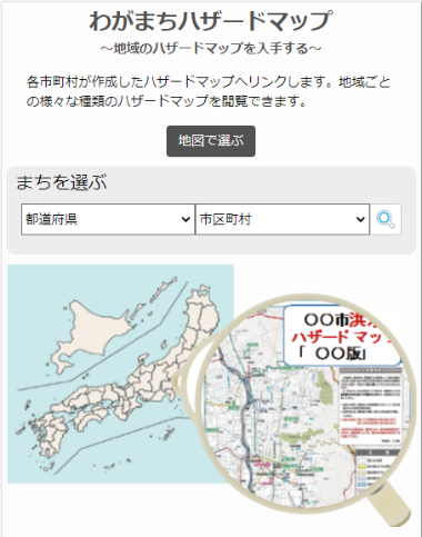
| 『Wagamachi Hazard map』 | |
| Link | https://disaportal.gsi.go.jp/hazardmap/index.html |
| Contents | You can search for Hazard Maps created by cities, towns, and villages across Japan by map or
disaster type. Please see the information listed below. Flood Hazard Map Inland Water Hazard Map Storm Surge Hazard Map Volcanic Hazard Map Tsunami Hazard Map Landslide Hazard Map Reservoir Hazard Map Seismic Damage (Strength of the earthquake’s activity and size) map |
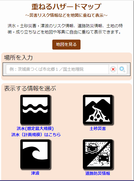
| 『Kasaneru Hazard Map』 | |
| Link | https://disaportal.gsi.go.jp/maps/ |
| Contents | Disaster risk information that helps in disaster prevention can be freely displayed over maps and
photos. The following information is available: Flood inundation hazardous areas: Areas of potential inundation due to river flooding and the depth of inundation. Flooded roads potential areas: Areas where heavy rains may cause flooding and submerged vehicles or the cause of other serious accidents (e.g., underpasses). Emergency transportation roads: Important roads that must be secured for emergency vehicles traffic for rescue, evacuation, supplies, and other emergency operations. Advanced traffic regulation sections: Sections where roadblocks and other restrictions are enforced before a disaster occurs, based on the standards established for regulating areas at risk of landslides and rockfalls due to heavy rainfall and other factors. In addition, you can check the following information: Reservoir inundation hazardous areas Tsunami deluge in hazardous areas Sediment disaster-prone areas and sediment disaster hazard areas Priority snow removal section Aerial photographs from the past to the present Land Condition map Land Condition map for coastal sea areas Landform Classification Map for flood control Low Marshy Areas of the Meiji Period Map Active Fault Map Basic Volcanic Map and Volcanic Land Conditions Map Color Elevation Map Color Elevation Map that you can create yourself Large Fill Development Site |
3.What to do when a typhoon is approaching
When a typhoon is approaching, stay in a safe place until the typhoon passes by checking the latest weather information on the TV, Internet, or radio.
- What to do when a typhoon is approaching
If a typhoon approaches, please pay attention to the following points.
- Do not go outside
Strong winds may cause things to blow away, and knock down trees, and utility poles. Also, heavy rain may cause the roads to flood and become as deep and treacherous as a river. It is very dangerous to walk on these roads as you can easily fall down into the water or fall into a manhole with the lid off. - Do not go out at night
Visibility is even worse at night and the danger level increases, so avoid evacuating at night. If there is a possibility that you may need to evacuate at night, please consider the following precautions. Even if you think the rain and winds are not that strong yet, you should consider moving while it’s still light outside. - Do not work outside
There is a risk of injury from gusty or stormy winds.
Things may blow around and cause injuries. Take caution to finish your work outside before the typhoon approaches, or after the typhoon has passed completely. - Keep away from rivers
Even if it is not raining in your area, heavy rains may suddenly occur, and the volume of water in the river may increase rapidly heading upstream.
- Keep away from the shore
High tides and storm surges can occur which is very dangerous.

- Keep away from mountains and cliffs
Heavy rains from typhoons can lead to cliff collapse.
If your home is on the side of a mountain, stay in a room on the upper floor, far from the mountain.

Avoid any other activities that may be considered dangerous.
Also, don’t let your guard down even if the rain stops.
The ground contains a lot of rainwater which makes it prone to landslides.
② Confirmation of the distribution of risks (landslides, floods from inland waters and floods from rivers)
You can check the distribution of risks of landslides, floods from inland waters, and floods from rivers on the JMA website.
Check to see if there is any risk of potential disasters in your area at this time.
- Risk distribution of heavy rain warnings (landslide disasters)
https://www.jma.go.jp/jp/doshamesh/index.html
- Risk distribution of heavy rain warnings (floods from inland waters)
https://www.jma.go.jp/jp/suigaimesh/inund.html
- Risk distribution of heavy rain warnings (floods from rivers)
https://www.jma.go.jp/jp/suigaimesh/flood.html
Extreme caution is required in certain parts of the hazard distribution, especially those marked in dark purple.
Dark purple indicates the highest risk, indicating a serious disaster is likely to occur.
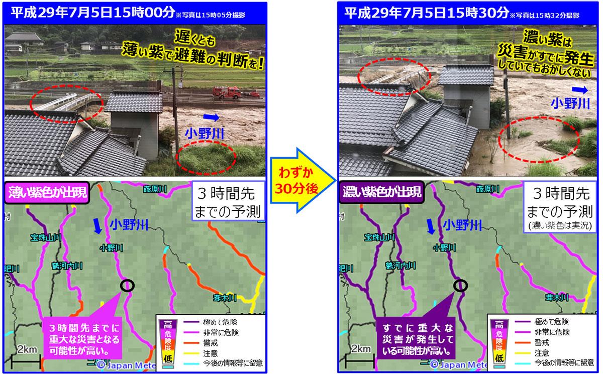
(Information from Government Information Online; photo courtesy of staff members of Hita City, Oita Prefecture; images courtesy of the Japan Meteorological Agency)
Also, don’t get complacent even if you think it’s still in the red or yellow stage of the degree of the risk, since you still should be careful.
As you can see from the photos, the impact of the rain has changed faster than you could imagine. For example, the light purple stage of the river increased to the dark purple level in 30 minutes.
Therefore, if you live in a landslide warning area or an area where there is a risk of river flooding, you should evacuate as soon as possible.
In particular, if it is already raining heavily and more rain is expected, you should evacuate immediately.
Regardless of the risk distribution, if your local government issues an evacuation advisory, you should evacuate to a safe place as soon as possible.
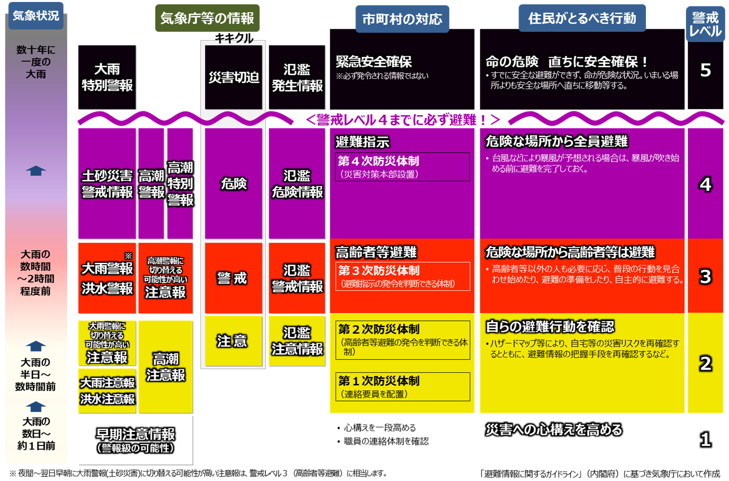
③ Pay attention to the alert level
Check the circumstances in your area based on the information released by the Japan Meteorological Agency when necessary.
You should pay particular attention to the timing of your evacuation and check your evacuation behavior on your hazard map on a daily basis.
✔ There are 5 levels of warning. The elderly, disabled, infants, and toddlers should evacuate from dangerous areas at Level 3 and everyone else should evacuate at Level 4.
✔ Alert Level 5 are circumstances where a disaster has already occurred!
| Alert Level | Actions Residents Should Take | Information on the municipalities based on the Japan Meteorological Agency | Weather Information | ||||
|---|---|---|---|---|---|---|---|
| Information on Rain | Information on Storm Surge | Information on Risk Distribution | Flood Information | ||||
| 1 | Improving Disaster Preparedness | Early Advisory Information(Possibility of a warning) | A few days to about a day before the heavy rain An hour or two before the heavy rain Heavy rain that falls once every few decades |
||||
| 2 | View the hazard map and confirm the evacuation activities |
Heavy rain advisoryFlood advisory | Storm Surge Advisory | Advisory (Possibility of an advisory) |
Flood Advisory Information | ||
| Advisory likely to switch to heavy rain warning | |||||||
| 3 | If you live in a hazardous area such as the sediment disaster warning areas or along a river where there is a risk of rapid water level rising, start evacuating as soon as you are ready to evacuate. The elderly, disabled, infants, and toddlers should evacuate immediately. | Heavy rain warning(※1) Flood warning |
Advisory likely to switch to storm surge warning | warning (Possibility of a warning) |
Flood Warning Information | ||
| 4 | Evacuate immediately・Immediately evacuate to a safe place outside the danger area | Sediment Incident Alert Information | Storm Surge Warning(※2) | Storm Surge Emergency Warning | High Risk | Flood Risk Information | |
| Complete the evacuation・Evacuation may already be difficult due to road flooding or landslides and should be completed before this situation occurs | Extreme Risk | ||||||
| 5 | If you are not yet evacuated from dangerous areas, take the best possible action to save your life.・When a heavy rainfall warning is announced, you must consider the fact that there is an urgent situation that increases the risk of a disaster even in places that are not considered to be at risk | Heavy Rain Emergency Warning | Flood Occurrence Information | ||||
(※2)An advisory that is likely to switch to a storm surge alert when a strong wind alert has been issued is equivalent to an evacuation advisory (Alert level 4)
This is a re-edited version of a table prepared by the Japan Meteorological Agency with reference to the “Guidelines for Evacuation Advisories” (the Cabinet Office, 2017).
(https://www.jma.go.jp/jma/kishou/know/bosai/images/arasute_5.png)

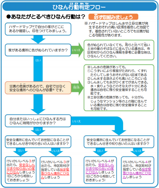
④ Decide whether you should evacuate
In case of deciding whether or not to evacuate as a typhoon approaches, you can refer to the decision flowchart and alert levels issued by the Cabinet Office.
- Use the evacuation decision flowchart
Please refer to the following flowchart to determine evacuation due to a typhoon or heavy rainfall.
「The Evacuation Decision Flowchart」(Source: The Disaster Prevention Information page of the Cabinet Office)
- Decide by the alert level
If the Alert level 3 or 4 is issued in your area, you should evacuate to a safe place as soon as possible.
Evacuation advisories are issued by your municipality, not the Japan Meteorological Agency.
When municipalities transfer evacuation advisories, they will announce the information as follows.
- Emergency broadcast, Emergency broadcast, Alert Level 4!Start evacuation.
Emergency broadcast, Emergency broadcast, Alert Level 4! Start evacuation. - This is XX City. Alert level 4 for floods, an evacuation advisory has been issued in the XX area.
- The water level of the XX river has reached the level of possible flooding.
- All residents in the XX area should evacuate immediately from the dangerous area.
- If it is not safe to evacuate to an evacuation site, please evacuate to a nearby safe place or take refuge indoors in a high place.
(Source: The Cabinet Office (in charge of disaster prevention) and the Fire Department)
✔ What is important here is the awareness that you should “save your own life”.
If you feel that you are in danger, even without instructions or warnings from your municipality, evacuate immediately to a safe place.
✔ Also, Alert Level 5 is a situation where a disaster has already occurred!
At this level, even moving to an evacuation shelter can be dangerous.
Assess the situation calmly and do the best you can to save your life.
It is also important to talk to your neighbors and cooperate with each other when you evacuate.

4.Predictors of Sediment Disasters
” Sediment disasters” are one of the most common disasters to watch out for when it rains heavily.
There are many mountains with steep slopes in Japan, typhoons, and heavy rain can cause debris flow, cliff collapse, and landslides.
To avoid such disasters, it is important to understand the risks of natural disasters around you using hazard maps, and to evacuate to a safe place as soon as you notice the signs of disasters.
Even after the rain stops, localized torrential rains, and prolonged periods of rain can be dangerous due to the increased risk of landslides. Watch out for them.
- Cliff Collapse
Cliff collapse is the sudden collapse of a slope, close to the ground, as a result of rain inundation or an earthquake.
If a cliff collapse occurs near homes, people may be unable to escape and may lose their lives.
Before a cliff collapse occurs, the following precursory phenomena may be seen.
- A crack develops in the cliff
- Pebbles begin to fall
- Water gushes from the cliff
- Tap water stops or becomes muddy
- The earth rumbles
- landslide
This is a phenomenon in which water in the ground and gravity causes part or all of a slope to move downward slowly.
Since the amount of soil being moved is significant, the damage can be very large.

Before a landslide occurs, the following precursory phenomena may be observed
- Cracks or crevices from in of the ground
- Water gushes from cliffs and slopes
- The water in wells and streams becomes muddy
- The earth and mountain rumbles
- The trees will lean
- Cracks and unusual bulges in the ground occur
- Debris flow
This is a phenomenon where it rains for a long period of time or a torrential downpour pushes stones and sediment from the riverbed or hillside downstream in one fell swoop.
As sediment flows downstream at speeds of 20 to 40 km/h, it can devastate homes and fields in an instant.
Before a debris flow occurs, the following precursory phenomena may be seen:
- The mountain rumbles
- The water in the river suddenly becomes muddy and driftwood begins to mix
- It smells like rotten dirt
- The water level of the river keeps dropping, even though the continues
- Hear the cracking of trees and the clashing of rocks
If you notice any of these warning signs, evacuate to a safe place without waiting for an evacuation orders or advisories from your municipality.
5.Disaster Emergency Message Service
When a major disaster occurs, such as a typhoon, it can be difficult to get through to the affected areas due to the rush of calls confirming the safety of family members and acquaintances.
For this reason, telecommunication carriers provide “Disaster Message Services” to help people confirm their safety and evacuation locations while avoiding communication congestion.
| Disaster Emergency Message Dial(171) | |
|---|---|
| Service Details | In the event of a disaster, voice messages such as safety information are registered to a phone number. The person with who has the phone number can play and check the registered voice messages. |
| Language Supported | Japanese |
| How to use | 1. Dial 171 2. Dial 1 for recording and 2 for playback in accordance with the guidance. You can also record and play back with your PIN here. 3. Follow the guidance and dial the phone number of the person you want to contact. For phone numbers that begin with an area code, such as 03, dial starting with the area code. 4. Record and play back the message. |
| Available Phones | Subscribed telephones (touch-tone line and dial line) Public telephones ISDN Mobile phones・PHS IP phone ✔ Registration and replay of the message must be made to the phone number of the person in the affected area. For this reason, phone numbers that begin with an area code such as 03, mobile phone/PHS phone numbers, and IP phone numbers are included. |
| Notes | The recording time per message is limited to 30 seconds. You can register up to 20 messages per phone number. If the number of stored messages exceeds the limit, the old messages will be deleted. |
| Reference Links | You can check the details of the Disaster Message Service, Dial at NTT’s (East and West), service
operator. NTT http://www.ntt.co.jp/saitai/171.html NTT East http://www.ntt-east.co.jp/saigai/voice171/ NTT West https://www.ntt-west.co.jp/dengon/ |
| Disaster Message Board | |
|---|---|
| Service Details | People in the affected areas can register messages by text using the internet connection function of their mobile phones or PHS, and then check the messages from all over Japan based on their mobile phone or PHS number. |
| Language Supported | Japanese, English |
| How to use | How to register messages 1. Access the Disaster Message Board from a mobile phone or PHS 2. Select “Registration” for “Disaster Message Board”. Registration is only accessible from mobile phones and PHS in the affected area. Choose a comment about your current state from options such as “I’m fine.” and enter a comment of up to 100 words optionally. You can use multiple selections of comments to indicate the current status, or use only free comments 3. Finally, press “Register”. How to check the messages (also possible via PC) 1. Access the Disaster Message Board NTT docomo http://dengon.docomo.ne.jp/top.cgi KDDI(au)http://dengon.ezweb.ne.jp/ SoftBank/Y!mobile http://dengon.softbank.ne.jp/ 2. Select “Confirmation” for “Disaster Message Board”. 3. Enter the mobile phone/PHS number of the person whose safety you want to check and press “Search”. 4.From the list of messages displayed, select the message you want to check. |
| Notes | You can register up to 10 messages per phone number. Messages exceeding the number of messages will be overwritten from the oldest ones. Messages are stored until the disaster message board for one disaster ends. |
| Reference Links | For more information on Disaster Message Boards, please check the pages of each company. NTT docomo Disaster Message Board Service https://www.nttdocomo.co.jp/info/disaster/disaster_board/index.html KDDI(au)Disaster Message Board Service https://www.au.com/mobile/anti-disaster/saigai-dengon/ SoftBank Disaster Message Board/Disaster Voice Messaging Service https://www.softbank.jp/mobile/service/dengon/ Y!mobile Disaster Message Board Service https://www.ymobile.jp/service/dengon/ |
| Disaster Message Board(WEB171) | |
|---|---|
| Service Details | You can register and check messages regarding safety information by entering the phone number of your landline phone, mobile phone, or PHS from your PC or smartphone. |
| Language Supported | Japanese, English, Korean, and Chinese languages |
| How to use | 1. Access the Disaster Message Board (web171) URL:https://www.web171.jp/ 2. Enter the landline or mobile phone number of the person you want to contact. 3. Register or confirm the message. Users can also be limited by setting it up in advance. Messages can be registered as text, with a maximum of 100 double-byte characters per message. |
| Notes | You can register up to 20 messages per phone number. Registered messages are stored for up to six months until the end of the service. |
| Reference Links | For more information on the Disaster Message Board (web171), please refer to the following NTT (East
and West) pages. NTT East http://www.ntt-east.co.jp/saigai/web171/ NTT West https://www.ntt-west.co.jp/dengon/web171/ |
| Disaster Voice Messaging Service | |
|---|---|
| Service Details | A dedicated application is installed on a smartphone or other device and voice messages are sent. Voice messages can also be sent between carriers that provided this service. |
| Language Supported | Japanese, English |
| How to use | 1. Enter the following keywords in Google Play or Apple Store to search for the app.NTT
docomo:「Disaster Kit」KDDI(au):「au Measures in Times of Disaster or Emergency 」SoftBank:「Disaster
Message Board」Y!mobile:「Disaster Message Board」 2. Download and install the dedicated application. 3. Start the application and follow the instructions. |
| Notes | Registration time is limited to 30 seconds per message. You can register up to 20 messages per phone number. Registered messages are deleted when the recipient downloads them. Even if not downloaded, the messages will be deleted after a certain period of time. |
| Reference Links | For more information on the Disaster Voice Messaging Service, please refer to the pages of the
operating mobile phone companies. NTT docomo https://www.nttdocomo.co.jp/info/disaster/disaster_voice/ KDDI(au) https://www.au.com/mobile/anti-disaster/onsei-otodoke/ SoftBank https://mb.softbank.jp/mb/service/dengon/about/voice/ Y!mobile https://www.ymobile.jp/service/dengon_voice/ |

・The above content is based on the following information. If there are any changes in the references, please be aware that it may take some time for the changes to be reflected on this site.
【Source】
・『Preparing for heavy rain and typhoons』(pdf), Japan Meteorological Agency(JMA)
http://www.jma.go.jp/jma/kishou/books/ooametyphoon/ooametyphoon201903.pdf
・「Examples of Meteorological Events Causing Disasters (1989–this(current) year)」,JMA,Ministry of Land, Infrastructure, Transport, and Tourism(MLIT)
https://www.data.jma.go.jp/obd/stats/data/bosai/report/index_1989.html
・「preparedness yourself for a disaster」,JMA,MLIT
https://www.jma.go.jp/jma/kishou/know/ame_chuui/ame_chuui_p10.html
・「What is a superimposed hazard map? What is our town hazard map? Easily investigate the disaster risk」(pdf),Hazard Map Portal site、MLIT
https://disaportal.gsi.go.jp/hazardmap/pamphlet/pamphlet.pdf
・「Pay attention to weather information for heavy rain and typhoons and take disaster prevention and evacuation measures as soon as possible」,Public Relations Office of the Government of Japan
https://www.gov-online.go.jp/useful/article/201206/1.html
・「Three points to protect yourself from landslide disasters!」,Public Relations Office of the Government of Japan
https://www.gov-online.go.jp/useful/article/201106/2.html
・「Revision of the guidelines for evacuation advisories (March 29, 2019)」,Disaster Prevention Information Page, Cabinet Office
http://www.bousai.go.jp/oukyu/hinankankoku/h30_hinankankoku_guideline/index.html
・「Disaster Message Service」,Ministry of Internal Affairs and Communications (MIC)
https://www.soumu.go.jp/menu_seisaku/ictseisaku/net_anzen/hijyo/dengon.html